Saturday, June 20, 2015

Almshouse in Maps: 1872 Beers Map of Mount Pleasant


The next map to feature the Westchester County Almshouse was published in 1872: the Beers Atlas of Westchester. I feel like this map is a lot more detailed than the 1867 one, or perhaps there has just been a lot of change in five years. For instance, Tarrytown Heights is mapped out, likely showing a recent subdivision that would be parceled out in lots in later years. Despite the encroachment of the subdivided areas on the countryside surrounding East Tarrytown, most of the houses and house owners remain the same.


Furthermore the almshouse itself appears to be virtually unchanged, with the same four buildings arranged next to the river; though it's now labeled as "County Alms House" instead of "County House Hospital."

Here's the full map for some context:

Thursday, June 18, 2015

Almshouse in Maps: 1867 Beers Atlas

So far, this is the earliest map I've been able to locate that shows the County Almshouse. Printed by Frederick W. Beers in 1867, it identifies the almshouse as "County House Hospital" and places it in the hamlet of East Tarrytown, near the place where the Saw Mill River changes directions from south to west, forming an angle. You can see that the hospital complex consists of three small buildings and one long one, standing adjacent to one another on the west side of the river.

There are quite a few farmsteads and houses located along the Saw Mill, as well as the S&G Mill. In the left of the detail above, you can see marked "W. Landrine - House where Andre was brought after his capture." This is the Landrine House, pictured below in The History of Tarrytown and Sleepy Hollow, which was at that time owned by the Reed family. It no longer exists.

Virtually the entire hamlet of East Tarrytown - also known as Eastview - was destroyed in the creation of the Saw Mill River Parkway, and the topography of the area was significantly impacted. Thus it is a bit tricky to correlate the old maps with what is currently there, but I'm working on it. 


I am hoping to learn more about the almshouse when I visit the Westchester County Archives again, which contains all of the almshouse records, beginning with the opening of the almshouse in 1828. Up until that year, the individual towns provided for their respective poor populations. The almshouse centralized and systematized the care provided to the county's poor.

Update: Summer 2015


Hello, everyone! After a long hiatus (thanks, grad school), I am back and planning to add lots of new discoveries to this blog. Most of them will be centered around my Master's thesis, currently in the works. In case you're interested, this is the abstract of my thesis proposal, titled "Excavating Personhood in the 19th-century Graveyard":
The St. George’s/St. Mark’s Cemetery in Mount Kisco, New York, offers an ideal site in which to investigate the construction of 19th-century middle-class personhood through intersectional processes. Previous studies have generally conceptualized the gravestone either as a passive reflection of social realities or as a site of the momentary suspension of social difference. The proposed study will marshal historical and archaeological evidence in demonstrating how gravestones functioned as active participants in the articulation of class- and gender-based identities and accordingly, in the negotiation of power. The gravestone represents a crucial player in the performance of middle-class habitus as it was staged throughout the 19th century. Though tied to larger historical movements, the construction of the American middle class took place within the realm of everyday material practice, in which the gravestone constituted an instrument for the enactment of embodied dispositions. By revealing the contingencies surrounding the formation of middle-class personhood, this study will denaturalize the categories that organize both historical and present-day social realities.
I am excited to share the results of my research so far, which has been undertaken mainly at the Westchester County Archives in Elmsford and the Mount Kisco Historical Society. I may also end up visiting the New York Public Library, the Municipal Archives in Manhattan, and even the State Archives at Albany.

My research mainly involves people and things: who those people were, and how they created, expressed, and maintained those identities through things. More specifically, how did various realms of material culture collude in the creation of a middle-class identity, and how was that identity asserted against its "Other," the marginalized classes of the poor?

Perhaps the most illustrative example of this process I can give is that of the St. George's/St. Mark's Cemetery, an 18th- and 19th-century middle-class graveyard that has been immaculately preserved throughout the years, in juxtaposition with the 19th- and 20th-century graveyard of the Westchester County Almshouse, which is currently sealed beneath a highway. The historical boundary between the middle class and the poor continues to be enforced into the present, so that the poor become as marginalized in death as they were in life.

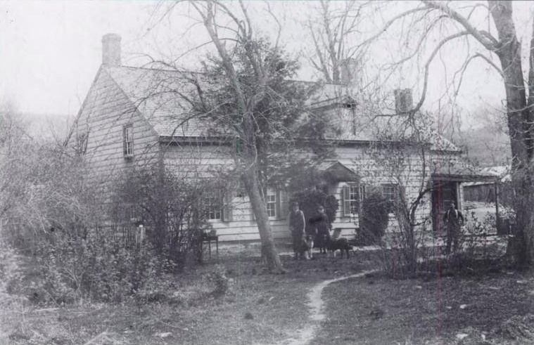
Over the next few months (before I head back to school), I hope to use this blog as a place to share my research and test out some ideas before they become processed and packaged into the body of my thesis. For now, here's a first glimpse of the Westchester County Almshouse as it appeared around the turn of the century, courtesy of Harvard University Library.

Saturday, November 1, 2014

Field Day 13


Due to several factors - including the rapidly dropping temperatures and Laurie's and my busy schedules -yesterday was our last dig day for this season. Of course, this in no way marks the end of our work on the site, as the end of fieldwork just means that processing and analysis are yet to begin. For every day spent in the field, you can expect to have at least three days of processing and analysis, and the ultimate working of the material into a finished product (i.e., an article or thesis) can take even longer than that.

Our last day in the field did not disappoint. We have been finding pieces of this transfer-printed teacup (or perhaps multiple teacups with the same pattern) for over a year now. This is by far the biggest piece we have found, and wouldn't you know, it has a registration mark!


This mark allows us to date the design securely to the year 1886. However, the actual teacup could have been made later than that - thus, the mark provides us with a terminus post quem. This website is a great resource for identifying registration marks. The system was implemented by the British Patent Office, which means that this teacup was made in Britain. We also found the handle of the teacup and a number of other pieces. I think it's a good candidate for reconstruction.

Other exciting finds included this bottle marked "Hygienic Laboratory" (which, according to the internet, was the first incarnation of the National Institutes of Health, from 1891-1930):


This intact bottle marked "McMonagle and Rogers Premium Fruit Flavors, Middletown NY":


These pieces of feather-edged or shell-edged ware. I think it may be pearlware but I'm not positive. It may date from the late 18th to the early 19th century and would have been made in England.


And ... these things (below). The top one seems to be some sort of charm. The bottom one - well, we debated whether it was a bird's head or a bell (or both?). It seems to have been squished a bit, and there's a clapper inside. Is it just a coincidence that it looks like a bird?


During our work on the dump, Harry and Bruce managed to excavate the gravestone that the team located on Monday. It's definitely a footstone, marked with the initials R. S. But who was R. S.? We still don't know. Sands, Sarles, Seaman, See, Sherwood, Slagle, Smith, Stanton, Stokem, and Swain are all the S surnames in the cemetery (that we know of). One thing we do know is that this was not the original location of the footstone. It's been broken at the base, and the rest of it is nowhere to be found.


Other than the footstone, the finds we made in the dump yesterday were pretty typical of what we've found here over the past year: ceramics of all kinds, glass, metal, shoe leather (along with some very corroded buckles), shells, a piece of molded cement, a few nails, a single glass button, animal bones, some additional pieces of teapot, and some steel wool. We didn't find any more pipe bowls or stems. But we did find two ice skates.


As always, those of us who were sorting and bagging the finds struggled to keep up with those who were digging and screening for them. You can see in the photo above how our process works - it's somewhat like a conveyor belt, with bucketfuls of dirt being dumped into the screen at the far end and working their way down the tables to be bagged. At the end of the day, the bags are placed in a milk crate to be temporarily stored in my garage until they can be transferred to the Nature Center for processing (planned for this winter).

Meanwhile, Laurie oversaw the backfilling of the foundation wall unit (Feature 4). This has been our largest unit yet (unless you count all of the units we have dug on the dump was one unit, dug in segments), and it required a lot of manpower to fill in!


To summarize, briefly, our finds for the season:

1. In Feature 4, the "foundation wall" unit, we found a continuation of the feature we identified last year, and ended up tripling the original unit in order to follow it. To the 4 x 8 foot rectangle we dug in fall 2013, we added two additional 4 x 8 foot rectangles directly adjoining each other on the long sides, working westward, so that by the end a 16 x 8 foot rectangle was exposed (16 feet East-West, 8 feet North-South). We excavated around the stones down to the subsoil, leaving what we believed to be the contours of the stone wall in place. The finds we made in Feature 4 were mainly architectural (nails, mortar, slate tiles, some possible pieces of a wooden floor, ashlar stones, window glass) with some notable exceptions (earthenware pottery sherds, lamp glass, milk glass, and pieces of a mason jar; from last year, a gunflint and a stone pestle). 

Feature 4A was our original unit, excavated last year. In this unit, in fall 2013, we found what looked to be a discrete, fairly intact stone wall, consisting of stones stacked on top of one another. Some crumbly white mortar was found between the stones and a handful of stones were found to be mortared in place. When we opened Feature 4B, adjoining Feature 4A on its western side, we found a much more scattered assemblage of stones that had no clear structure or pattern. By Feature 4C, the stones seemed to be arranged in a more coherent manner, and mortar was clearly used to fix them in place. It was also in Feature 4C that we found that the slate tiles we had found throughout 4A and B were clearly packed between the stones along with the mortar, suggesting that the feature was constructed this way. That is, the slate tiles were originally used as building materials, and didn't wind up in the stone wall when the roof collapsed, as I had suspected earlier.

We completed and backfilled the unit when we reached the end of the season. Based on our finds in Features 4A-C, we expect that the stone wall may continue westward in the area we have not yet dug. It is likely that we will open an additional unit (Feature 4D) in this location in our next field season. Laurie also raised the possibility of placing a unit between Feature 4 and Feature 1 (formerly referred to as the "dry well," which contains a large amount of architectural debris, including boulders with plug and feather marks, stencil-painted window glass, nails, and painted plaster) to see if we can establish a relationship between them.

My working hypothesis is that Feature 4 represents the foundation wall of one of the churches, most likely (due to the construction of the wall and the artifacts associated with it), St. George's Church. After finding ashlar stones in the stone wall that surrounds the cemetery, Laurie put forward the theory that after St. George's was deconstructed in 1819, the top layer of stones of its foundation were used to construct the stone wall, while the bottom layer of stones were left in place and buried (or became buried over time). We know that the proceeds from the sale of the frame of the old church were used to build the stone wall. This is circumstantial evidence, of course, but I find it very compelling! It also explains why there are ashlars in the stone wall, when typically stone walls in this area are made of unshaped stones. 

2. In Features 6-10, the "dump," we continued to find large amounts of densely packed artifacts spread over a large area alongside the stone wall of the cemetery and extending about 20 inches below the surface, with the largest concentration of artifacts between 5-10 inches below the surface. This arrangement seems highly suggestive of a dump, and in particular one that was used over a long period of time (perhaps as early as the late 18th century, and continuing into the 20th). This period coincides with the period of use of the site as a churchyard and cemetery, and most of the artifacts seem to date from the years when the cemetery was in most frequent use (the mid-19th century). It's certainly possible that the parishioners of St. George's and St. Mark's Church dumped their refuse here. It's also possible that their neighbor to the south, the Methodist Church (which later became a residence, a parsonage, and a hotel), and their neighbor to the west, which was occupied by a house as early as the 1860s, contributed to the pile.

There is a lot we can learn about the 18th- and 19th-century community from what it threw away, and almost endless avenues open for investigation. Just a few stray observations:

-An earthenware tobacco pipe suggests that someone in the early 19th century was using local clay to manufacture pipes, despite the profusion of cheap tobacco pipes imported from England. How widespread was this local manufacture? Was it just one producer or many? What would make someone choose a locally manufactured pipe over an imported one?

-Multiple teapots, teacups, plates, and serving dishes attest to the popularity of tea drinking in the area along with a correspondent rise in conspicuous consumption. Almost anyone could afford their own tea set, choosing from a variety of different patterns and styles, and as soon as a piece was broken, it could be thrown away and replaced.

-A variety of soda bottles link our site to local bottle manufactories in the area (including one located just a mile away in the center of town), while medicine bottles attest to the use of dubious "cure-alls" containing potent ingredients such as morphine and liquor. The bitters bottle we found last year (we found more pieces this year) could have been used to treat the malaria that we know was endemic to the area throughout the mid- to late 19th century.

-Ice skates, a cap gun, a fishing hook, and a single jack suggest play and leisure activities during the 19th century. People had the time and money to spend on such activities, and children were provided with time to play and toys to fuel their imaginations.

-While the evidence linking them is circumstantial only, the shoes and eyeglass lenses we have found bring to mind the shoe and optical factories, respectively, which were located just down the road in the mid- to late 19th century. Whether or not these items came from these respective factories, the industry in the area played a large role in shaping the community to which the site belonged.

Friday, October 31, 2014

Annular Ware?


I came across this passage while re-reading James Deetz's classic In Small Things Forgotten a few days back, and was reminded of the finds that Hans made while resetting graves this fall (shown above):

"The bowls used by the Cannon's Point slaves for food consumption were largely of a type of pearlware known as annular ware. Annular ware is decorated with a series of concentric colored bands on the exterior of the bowls, placed horizontal and parallel. It was the second least costly of all the pearlware products of the Staffordshire ceramic industry and we often find it on sites associated with people who held a subservient station in life. Not only is it commonly found on slave sites over the entire South, but also in the Indian quarters at Franciscan missions in California and even at a fort occupied by Cape Colored regiment in nineteenth-century British South Africa. In every case, annular ware appears not to have been of hand-me-down status, but rather to have been acquired by those in control, to be issued at appropriate intervals. John Otto suggests that because of their distinctive type of decoration, 'they appealed to a steady group of customers,' including black slaves. But this seems very unlikely, and their presence at slave sites seems one more case of the planter's management of available capital. The appearance of annular ware on slave sites of the early nineteenth century may well mark the time when mass-produced English pottery became inexpensive enough to be purchased in quantity for issue to slaves, for as we shall see, another kind of bowl is typical of the eighteenth and late seventeenth century, produced by the slaves themselves."

Examples of annular ware (also known as mocha ware) from the internet:


Sources: 1, 2, 3, 4, 5.

What do you think?

Thursday, October 23, 2014

Field Day 12

Some of you may recall my very first post on this blog, which told the story of Dr. Enoch and Phebe Chase Greene, the unfortunate couple who married in 1845 and had both died by 1852, after losing three children. At the time I wrote that post (February 2013!), I knew of only two gravestones belonging to the five members of the Greene family: one for Enoch Greene, and one for his wife, "Freddy and two infants." On Monday's dig, in the process of restoration work, the team discovered a gravestone belonging to Freddy buried beneath (or more likely, subsumed by) the tree. This gravestone is particularly significant because it provides us with the (previously unknown) year of Freddy's death. Given the fact that this date is not mentioned in the 1910 transcription of the cemetery, it's likely that this stone has been buried for more than 100 years.


Above, the team excavating the base of Freddy's gravestone. Laurie hopes to get the entire group of Greene gravestones - Phoebe's broken stone, Enoch's tilted one, and the newly found Freddy stone - repaired and reset in the spring. Given the progress the team has made in resetting stones just this fall, I'd say that it's a viable goal.

Meanwhile, back in the dump, the team made an unexpected find: a footstone! Given the way that footstones have been distributed and redistributed throughout the cemetery, the finding of this stone here does not necessarily mean that anyone was buried in this location. Like the many displaced footstones we have found, we'd like to match this one to its owner. The problem is, I don't know of anyone buried in the cemetery who has the initials R. S. Was the owner of the footstone moved, along with his/her headstone, to another cemetery? We know that this was a relatively common occurrence. Or was the headstone destroyed or rendered illegible? Judging by the material (marble), this stone likely dates to the 19th century. It's very similar in style to many other 19th-century footstones in the cemetery.


Other than the footstone, the finds made in the dump on Monday were pretty much typical. Harry, Margaret, and John took turns digging and screening the soil.


Here you can see some of the results of their work: glass (including a very fancy medicine bottle), ceramics, metal, shoe leather, shells, some copper wire and nails ...

And Margaret excavated this shoe. I'm no shoe expert, but I'm guessing it's late 19th or early 20th century. What do you think?

Saturday, October 18, 2014

The Search for Spencer Optical


Here's a brief overview of the history of Spencer Optical Works, for those of you who may not have read my 5,000 posts on the topic over the past year. The business started in the 1850s in Connecticut and came to Kirbyville in 1874. For fourteen years, the factory thrived, powered by a force of 200 workers and the energy harnessed from the river running down from Kirby Pond. In 1888, however, the pond's owner, Judge Leonard, decided to drain the pond, cutting off the factory's power source. The Spencer brothers sued to protect their water supply but lost. The pond was drained, the Spencers established a new factory in New Jersey, and despite their effort to find a buyer for the property in Kirbyville, the three-story brick building remained silent and empty. At an unknown date, the factory and its outbuildings were torn down, and the forest has engulfed whatever was left.


That is not to say that there's nothing left to find. On this bright October day, armed with maps and old photographs, our group set out through the forest to find the place where the stream bends and starts flowing towards the town. It was at this bend that the factory was located. It didn't take us long to find evidence of a human presence, both historical and modern ... 


The picture at the top of the post shows our first major find: the stones of the former dam. But the pictures below give a sense of scale of what was really an incredible feat of engineering. We stood here for a while, looking around, contemplating how such a feat might have been achieved. Did the makers use horses or oxen to haul the stones? Where did they come from? A few, interestingly enough, had quarry marks just like the stones we've found in the dig (though these stones are much larger than anything we've found at our site). 


A part of the dam wall had tumbled out, creating a cave where the inside of the wall is visible. Smaller stones were packed between the larger ones, but it seems to have been entirely dry construction - that is, without mortar.


Here's the other side of the dam, where the water runs through the demolished wall. 


After exploring for a while, we committed the ultimate horror movie mistake of splitting up, and promptly succumbed to Optical Factory zombies. I'm joking, of course, but Bruce did cross the stream to look around on the other side while the rest of us went on a bit further and studied the map. After a while we heard Bruce yelling for us, and he came back with two bricks - our first physical evidence of the brick factory building. In fact, Bruce had come across a whole lot of bricks, which we now believe to be the factory site, but due to a number of factors (including the time, which was getting fairly late) we decided to save the exploration for another day. Rest assured we will be back, and doubtlessly there will be a lot more to see. Just in our trip to the dam we found an additional brick (stamped with JJJ) and a ceramic insulator, both of which could be contemporary with Spencer Optical. I hope you're as excited as I am to continue this adventure.