Tuesday, June 30, 2015

Enfield Street Cemetery, Enfield, CT

Enfield Street Cemetery had by far the best view of any of the cemeteries I visited this week. Set against green trees and blue hills, it's a rural cemetery that includes several 18th-century sandstones, many 19th-century marble tablets and obelisks, and modern stones. Obelisks have quite a different feel when they're arranged in clusters, like a marble forest, as opposed to in the St. George's/St. Mark's Cemetery, where they stand isolated, like lighthouses in a sea of shorter stones.


The first thing to catch my eye in this cemetery was the huge sandstone orbs positioned on top of these gravestones. There is one other set of such orbs in the cemetery, but it's only a pair. As you can see, it looks as though this stone began as a pair - Ephraim Pease and his wife Tabitha - but was transformed into a trio with the addition of second wife Rebekah. I have never seen orbs like this before, but they seem appropriate, given that orbs are widely used to symbolize eternity. Small stone orbs (about the size to fit in the palm of your hand) known as "petrospheres" have been found in Neolithic sites in Britain and Ireland. 


The color and shadows in these photos aren't the best, but I had to make do with a somewhat overcast sky and stones that were lit mostly from behind. A few times I was able to take advantage of other conference attendees who had brought a mirror with them to cast light on the stones; you can see the results below.


The weird insect-winged, sawtooth-chinned cherub on the right in the first picture was duplicated in other stones in this cemetery, as well as in the next one we visited. I was surprised by the material of this stone and the one next to it, which I hadn't seen before; it's a type of stone called schist, which contains tiny grains of micha that sparkle in the sun. I also like the epitaph on the second stone: "The State of Mortals here behold: For young must die as well as old ..." Thanks, people definitely wouldn't have known that in the 18th century.

Above, a sandstone marker with an hourglass and another schist marker with a cherub. The sawtooth edge on the chin of the cherub is thought to be a vestige of the teeth of the death's head, from which the cherub evolved (according to Allan Ludwig, author of Graven Images: New England Stonecarving and its Symbols, i.e. one of the best books ever written). The marker on the left would fit in perfectly with the stones at Longmeadow Cemetery.

These stones are oriented differently from the others, perhaps because they're from the 1750s. In the St. George's/St. Mark's Cemetery, the oldest stones are oriented westward, while the newer ones point eastward.

This stone has a shell-like tympanum, perhaps a symbol of baptism, or perhaps showing the influence of Rococo style (a.k.a. "Rocks and shells") - or both. The inscription is unusually descriptive: "The Aged Mr. Samuel Pease, Haveing faithfully served God, & his Generation to the Universal love & Acceptance of all Who Knew him, departed this life in hope of a better one ye 8 of Sep. 1770 in His 84th Year." Fun fact: there are eight separate Samuel Peases recorded in this cemetery on Find A Grave.

Another great hourglass, and notice that in this one you can see that the sand has run out. This is a very different image of a life ending than that evoked by the scythe cutting through a flower, and for good reason: while the former symbol was used mostly for young people (the life cut short) the latter was generally reserved for those who had lived a full life.

I'm sorry that I don't have a better image of this stone, as it features one of my favorite motifs: a likeness that looks much more like a portrait than a soul effigy.


Lastly, from a much later period, is this massive zinc obelisk, dating to 1883. Believe it or not, this stone is so massive that its base is buckling under its own weight (though you can't really see it in this photograph).

Sunday, June 28, 2015

Longmeadow Cemetery, Longmeadow, MA

This week I had the privilege of speaking at the 2015 Annual Conference of the Association for Gravestone Studies in Westfield, Massachusetts, as well as attending the lectures, workshops, and tours. My paper, in case you're curious, was titled "'The Fashionable Dead': The Rise of Gentility in an American Cemetery, 1760-1900," and was about the stylistic and cultural changes between the 18th and 19th centuries as demonstrated in the gravestones of the St. George's/St. Mark's Cemetery. My paper draws upon the scholarship of James Deetz, Edwin Dethlefsen, Robert Blair St. George, and in particular that of Richard Bushman, whose book The Refinement of America provided me with the conceptual distinction between 18th-century elite gentility and the 19th-century democratized or "vernacular" gentility.

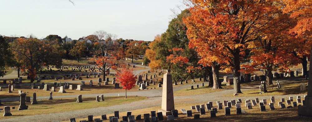
St. George's/St. Mark's has some truly extraordinary 18th-century stones, but there are only a handful of them. Imagine my delight when the first cemetery I visited on the Connecticut River Valley Sandstone tour was filled with dozens upon dozens of 18th-century sandstones, many of them far earlier than the ones in our cemetery, all arranged in neat rows stretching across the grass. The rows, of course, are a Victorian imposition, but the colonial stones are immaculately preserved. This is Longmeadow Cemetery in Longmeadow, Massachusetts.


Once you've visited quite a few cemeteries (like me), you start to get a feel for what distinguishes one from another. There is a notable tension between the homogeneity of iconography (for example, the death's head and the cherub are ubiquitous) and its differentiation between locations, carvers, and time periods. The St. George's/St. Mark's Cemetery preserves a direct stylistic link between lower New York State and the Connecticut River Valley in the form of the stones carved by Solomon Brewer, a native of the CRV who moved to the Hudson River Valley in the late 18th century. Thus the stones that I have been researching for years are the stylistic descendants of the ones pictured here, and they share many obvious connections.

Yet there are many obvious differences too, such as the Baroque flamboyance of the stones pictured above and below, which exhibit a need to occupy almost every inch of available space with ornament. This is definitely pared down in the stones of the Hudson River Valley.

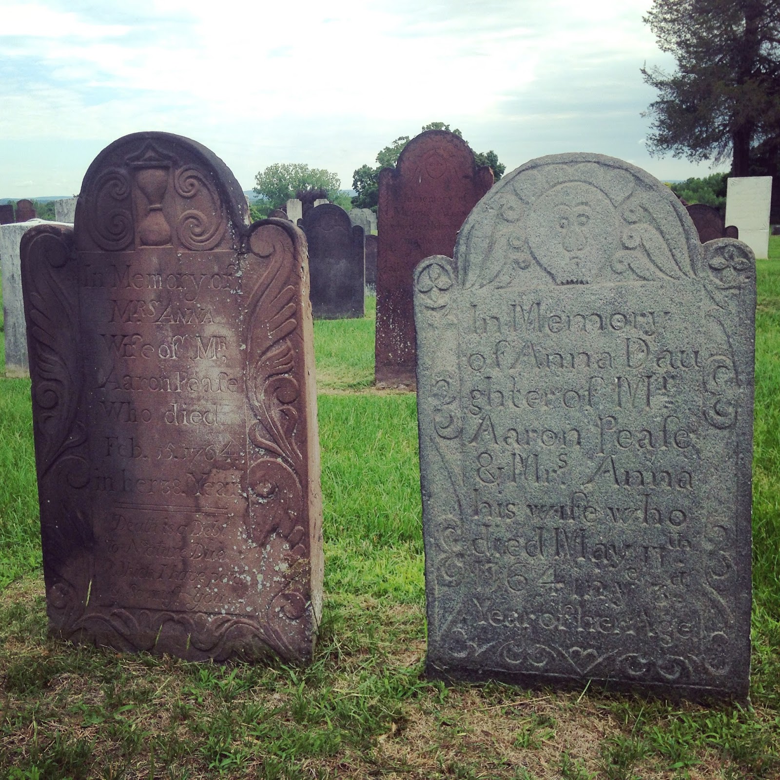
 Yet the basic elements of the cherub pictured above are preserved in Solomon Brewer's New York stones: cherub face, crown, and wings. Also notable: the color of the sandstone, which is much closer to brown than the red sandstones in the St. George's/St. Mark's cemetery. Though you can't see it (the flag is blocking it in the photograph) this stone is from 1765.

 This stone dated 1790 is crowded with ornament, including heart-shaped hourglasses, a sun floating above the cherub's head, and scalloped edges around the epitaph. But note the realism of the wings relative to the Ebenezer Colton stone; they are far less stylized, perhaps hinting at an incipient neoclassicism around the turn of the century. It is also a simple rectangle, as opposed to the earlier "bedstead"-shaped stones.

There is something distinctly Egyptian about this stone dedicated to two children of Nathaniel and Jerusha Taylor in 1801; perhaps having something to do with the contemporary campaigns of Napoleon in Egypt?

I am guessing that this stone was carved by the same person or in the same workshop as the stone above (Stephen Keep). I like that so many of the cherubs in this cemetery have pupils; it gives them a liveliness that is lacking in other, pupilless cherubs.

The rooster on the stone of Naomi Ritchard, dated 1760, was used as the emblem of the 2015 AGS Conference. It's a symbol of resurrection. The other icons are the hourglass and what looks like a scythe cutting down a stalk of wheat, a symbol of a life cut short.


I'm always happy when the full epitaph is visible; in so many stones, the last lines have sunken below the ground. "Our Life is ever on the wing / And Death is ever nigh: / The moment when / our Lives begin: / We all begin to Die." Cheerful!

Check out the scythe and hourglass at the bottom, rather than the top, of this stone, as well as the hairs sketched onto the cherub's head. Also notable in the background: on the left, an amazingly preserved table grave; on the right, one of the oldest (if not the oldest) stones in the cemetery, which I unfortunately didn't get a good picture of.

Gravestone of Samuel Ely, A. B., a graduate of Yale College, who died in 1772. "He was Meek Sedate / Quiet & Religious / He bore a Lingering Sickness / With Great Patience / he had not only hope but / Even Joy in his Death." My favorite stones are those that give personal information beyond that of the basic name, dates, and ages at death.

Another great stone with a scythe, this one cutting down a flower, appropriate for a woman who died in her 29th year. An unusual aspect of this stone is that the husband of "Mrs. Eunice" is not named, but her parents are. 

"Life is a bubble quickly broke / A tale forgot as soon as spoke." Incidentally this reminds me of the Emily Dickinson poem: "A word is dead when it is said / Some say - / I say it just begins to live / That day." (Yes, I visited Amherst while I was in Massachusetts.)

The fruits dangling from the vines in the stone on the right look like hearts. The "cherub" is more like a stylized portrait of the deceased, complete with coiffed hair. 


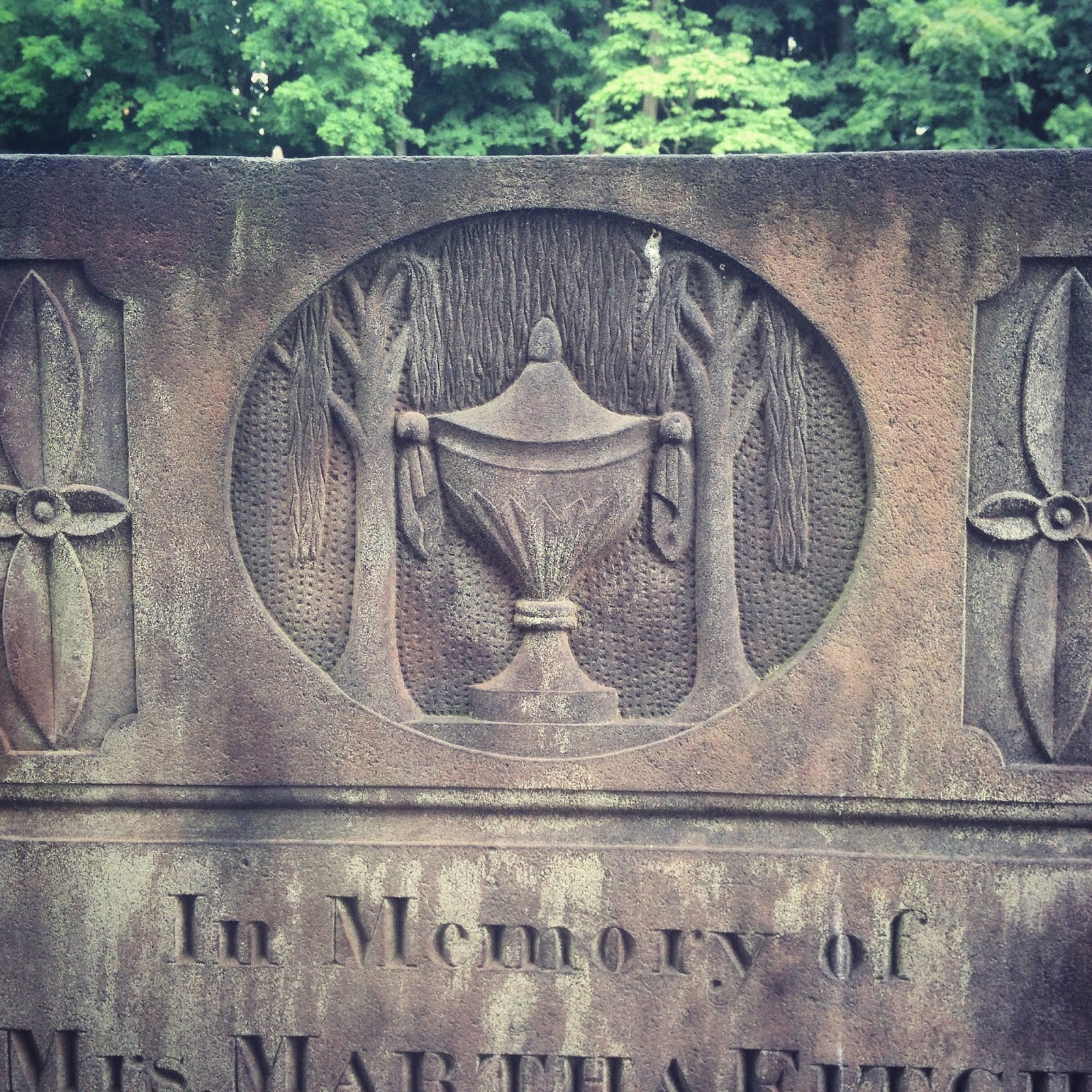
Finally, although I am not usually such a fan of urns and willows, I like that this one is cut in sandstone. The use of sandstone in the graveyards I visited persisted long after it had ended in the Lower Hudson Valley, even into the 1860s. In the St. George's/St. Mark's Cemetery, the parishioners had moved on to marble by 1820s.

Monday, June 22, 2015

The Almshouse in Photographs


These photographs, held by the Harvard University Library, depict the almshouse complex as it appeared around the time of the 1901 map. The image above is labeled "panorama from the rear." Looking at a modern topographical map of the area, there is a ridge that runs northwest/southeast along the present Saw Mill River Parkway, which I believe is the ridge in the picture. That could make the white line that you can see in the left background of the picture the road that runs on the west side of the almshouse complex; thus the picture (if I am right) was taken facing west. I could be wrong, but I have some further evidence (to be featured in a later post) that may help to confirm or deny my theory.


This photograph is labeled simply "almshouse," but if you note the four dormers and the Mansard-roofed building directly to the rear of it (and the smaller Mansard-roofed addition on the right), it seems to be the same building that is shown in the photograph below, labeled "Women's yard and rear of main building." This photo gives a sense of how many different phases of construction the almshouse has undergone. The photo above is also notable for the presence of people standing in front of the main building - are they residents of the almshouse, drawn outside by the novelty of the photographer in their midst?


Here's another photograph of the main building, which gives a better view of the stone facade, the many attached buildings stretching off to the right of the photo, and the decorative molding. I am intrigued by the white post running through the left foreground, which doesn't seem to be visible in the other photograph; is it a flagpole?


Another view of the main building and its attachments with stone wall, driveway, and trees in the foreground. Any guesses as to the reason certain tree trunks are white? This photo and the one above are labeled "Residence Buildings."


This is the front and rear views of the hospital. Notable: pediment, arched doorway, women on the porch (nurses?), stable or barn or some kind in the background, rear wings that look like an addition, fenestrated basement.


The photograph below is labeled "Laundry; dormitory for men on upper floors." You can see the washing hanging on the line in the foreground, attached to the tree (with the strange white-painted trunk). There seems to be a wood pile on the side of the building. Apparently the building was originally intended as a double house or dormitory, with its two off-center doors.


Labeled simply "barns." The almshouse complex was a working farm, and able-bodied inmates were expected to work for their keep. Those who couldn't do manual labor were given less strenuous tasks. 

Lastly, another view of the complex, showing the main building, gardens, and barns. I'm not sure where this photo would have been taken from, though I suspect it is looking west; perhaps the photographer was on the roof of another building.


Almshouse in Maps: 1914 Bromley Map


The 1914 Bromley map of Mount Pleasant offers a view of the almshouse in relation to Kensico Cemetery (see below) as well as a detailed view of the multiple buildings in the almshouse complex. There seem to have been eight buildings in the 1901 map -- one large and seven small -- whereas the 1914 map shows eight buildings of varying sizes, most larger than those shown on the 1901 map.


James Butler and John D. Rockefeller are still named as the landowners of the properties surrounding the almshouse complex. In the full map below, you can see that part of the land directly south to that of James Butler's has been parceled out as "Proposed filter beds New York City water supply." The development of the New York City watershed in Westchester County began in the 1890s. In Mount Kisco, it necessitated the destruction of a large portion of the downtown village.

Sunday, June 21, 2015

Almshouse in Maps: 1901 County Atlas


The next view of the almshouse, from the 1901 county atlas, is somewhat awkward, as the page cuts the area surrounding the almshouse in half. What is notable, however, is the relatively detailed view of the almshouse that this map provides. You can clearly see the large main building and many outbuildings, as well as the fact that the almshouse is sandwiched between two large estates belonging to two wealthy men, John D. Rockefeller and James Butler, respectively. In fact, the almshouse seems to be located on the property of James Butler. I am somewhat confused by the parcel marked "John Brown." Is this part of James Butler's estate, or a separate property? I expect I will find out when I get around to reading all of the material that I have recently accumulated!

Almshouse in Maps: 1893 Bien Map


I've made some pretty amazing discoveries about the almshouse since I last posted (or rather, some awesome people who read this blog provided those discoveries to me!) but I'd like to finish up with the maps before I share them here. This map is the 1893 Bien Map of Mount Pleasant and Ossining. As you can see, what was previously labeled as "East Tarrytown" is now known as "East View." This was the estate purchased by James Butler, a wealthy grocery store tycoon, the same year that this map was published. The hamlet of East View is somewhat similar to the old hamlet of East Tarrytown, with the same collection of small dwellings (though there seem to be fewer) and the almshouse (now labeled "County Poor House") -- but there are some notable changes, including the extension of the Putnam Division railroad in 1880, the construction of the Methodist Church, and the presence of another estate (Tower Hill/Kingsland Estate) nearby.

The overall trend seems to be toward greater consolidation and industrialization, which is gradually changing the landscape of the former small agricultural hamlet. The almshouse stood as a witness to these changes, but within a few decades its own existence would be threatened by local development.

Here's the full map for context:

Saturday, June 20, 2015

Almshouse in Maps: 1872 Beers Map of Mount Pleasant


The next map to feature the Westchester County Almshouse was published in 1872: the Beers Atlas of Westchester. I feel like this map is a lot more detailed than the 1867 one, or perhaps there has just been a lot of change in five years. For instance, Tarrytown Heights is mapped out, likely showing a recent subdivision that would be parceled out in lots in later years. Despite the encroachment of the subdivided areas on the countryside surrounding East Tarrytown, most of the houses and house owners remain the same.


Furthermore the almshouse itself appears to be virtually unchanged, with the same four buildings arranged next to the river; though it's now labeled as "County Alms House" instead of "County House Hospital."

Here's the full map for some context:

Thursday, June 18, 2015

Almshouse in Maps: 1867 Beers Atlas

So far, this is the earliest map I've been able to locate that shows the County Almshouse. Printed by Frederick W. Beers in 1867, it identifies the almshouse as "County House Hospital" and places it in the hamlet of East Tarrytown, near the place where the Saw Mill River changes directions from south to west, forming an angle. You can see that the hospital complex consists of three small buildings and one long one, standing adjacent to one another on the west side of the river.

There are quite a few farmsteads and houses located along the Saw Mill, as well as the S&G Mill. In the left of the detail above, you can see marked "W. Landrine - House where Andre was brought after his capture." This is the Landrine House, pictured below in The History of Tarrytown and Sleepy Hollow, which was at that time owned by the Reed family. It no longer exists.

Virtually the entire hamlet of East Tarrytown - also known as Eastview - was destroyed in the creation of the Saw Mill River Parkway, and the topography of the area was significantly impacted. Thus it is a bit tricky to correlate the old maps with what is currently there, but I'm working on it. 


I am hoping to learn more about the almshouse when I visit the Westchester County Archives again, which contains all of the almshouse records, beginning with the opening of the almshouse in 1828. Up until that year, the individual towns provided for their respective poor populations. The almshouse centralized and systematized the care provided to the county's poor.

Update: Summer 2015


Hello, everyone! After a long hiatus (thanks, grad school), I am back and planning to add lots of new discoveries to this blog. Most of them will be centered around my Master's thesis, currently in the works. In case you're interested, this is the abstract of my thesis proposal, titled "Excavating Personhood in the 19th-century Graveyard":
The St. George’s/St. Mark’s Cemetery in Mount Kisco, New York, offers an ideal site in which to investigate the construction of 19th-century middle-class personhood through intersectional processes. Previous studies have generally conceptualized the gravestone either as a passive reflection of social realities or as a site of the momentary suspension of social difference. The proposed study will marshal historical and archaeological evidence in demonstrating how gravestones functioned as active participants in the articulation of class- and gender-based identities and accordingly, in the negotiation of power. The gravestone represents a crucial player in the performance of middle-class habitus as it was staged throughout the 19th century. Though tied to larger historical movements, the construction of the American middle class took place within the realm of everyday material practice, in which the gravestone constituted an instrument for the enactment of embodied dispositions. By revealing the contingencies surrounding the formation of middle-class personhood, this study will denaturalize the categories that organize both historical and present-day social realities.
I am excited to share the results of my research so far, which has been undertaken mainly at the Westchester County Archives in Elmsford and the Mount Kisco Historical Society. I may also end up visiting the New York Public Library, the Municipal Archives in Manhattan, and even the State Archives at Albany.

My research mainly involves people and things: who those people were, and how they created, expressed, and maintained those identities through things. More specifically, how did various realms of material culture collude in the creation of a middle-class identity, and how was that identity asserted against its "Other," the marginalized classes of the poor?

Perhaps the most illustrative example of this process I can give is that of the St. George's/St. Mark's Cemetery, an 18th- and 19th-century middle-class graveyard that has been immaculately preserved throughout the years, in juxtaposition with the 19th- and 20th-century graveyard of the Westchester County Almshouse, which is currently sealed beneath a highway. The historical boundary between the middle class and the poor continues to be enforced into the present, so that the poor become as marginalized in death as they were in life.

Over the next few months (before I head back to school), I hope to use this blog as a place to share my research and test out some ideas before they become processed and packaged into the body of my thesis. For now, here's a first glimpse of the Westchester County Almshouse as it appeared around the turn of the century, courtesy of Harvard University Library.